The data captured at Jackson Hole with Site Scan for ArcGIS came out phenomenal as a result of the Terrain Follow feature. I don't think we could have captured the data we did without it.
Bobby Valentine, VCTO Labs

The Natural Selection Tour, a snowboarding competition sponsored by Red Bull, brought athletes to the Jackson Hole Mountain Resort in February 2021. Due to challenging terrain and weather conditions, Red Bull wanted to give snowboarders a tool to plan their routes ahead of time. The company turned to XR Media and VCTO Labs, media and technology firms that enlisted the help of drone mapping software. The goal was to give competitors a fully virtual experience before they hit the mountain slopes.
To create the best digital representation of the rugged competition trail with its trees, cliffs, rocks, and jumps, the VCTO team used drones and cutting-edge mapping software Site Scan for ArcGIS to capture high-quality imagery. The new Terrain Follow feature in Site Scan streamlined the collection of imagery by eliminating the need for repeat flights, and the geofence feature allowed them to automatically stay outside no-fly zones. The team was able to capture and process their data quickly using the automatic and repeatable features of Site Scan.
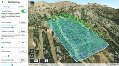 Area Survey flight mode with Terrain Follow enabled in Site Scan Flight for ArcGIS
The main objective of capturing drone imagery was to accurately virtualize the competition area. This included natural terrain, snow, trees, boulder fields, and natural and manufactured jumps. Mapping all the obstacles and jumps competitors could encounter on the mountain was a must. When they were done, athletes needed to be able to see the trail in 3D and virtually plan their run on a smartphone.
The rugged terrain—with its high elevation, steep average slope of 45 degrees, and 1,000 feet of elevation difference—made it difficult to fly drones and capture quality imagery. So instead of using time-consuming drone mapping techniques such as tiered area scans, the team turned to Site Scan for ArcGIS—end-to-end cloud-based drone mapping software for imagery collection, processing, and analysis.
Of special interest for this project was the Site Scan feature Terrain Follow, which allows a drone pilot to load 3D terrain data in the mission planning software. Then the drone can automatically follow the ground and keep a consistent flying height. This creates a detailed model of the slope, with constant image overlap and resolution throughout the flight, while maintaining a safe distance from the terrain.
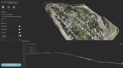 3D point cloud viewer with profile line in Site Scan Manager for ArcGIS
The team members were able to collect the quality imagery they needed in a matter of hours, despite severe winter weather. Once the team had set up the flights and decided what flight modes to use, the app took care of the rest and the data captured was excellent.
Due to no-fly zones nearby at the Grand Teton National Park, the Site Scan geofence feature was beneficial at Jackson Hole Mountain Resort. Enabling a geofence allowed the team to create a flight path that kept the drone within a defined polygon and preselected boundaries, avoiding obstacles while staying outside the no-fly zone.
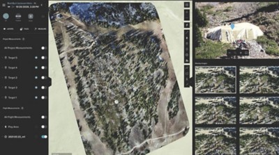 2D viewer (orthomosaic) with Photo Inspect tool in Site Scan Manager for ArcGIS
Because many areas on the mountain lacked cell service, the ability to download maps before a flight and view them offline helped the team as well. Once all the imagery was captured and the team members returned to a location with internet connectivity, they uploaded the data to cloud in Site Scan Manager for ArcGIS. There, it was processed into a 3D point cloud and mesh as well as a 2D orthomosaic high-definition map and elevation model. The process is fully automatic, enabling the team members to complete processing in only a few hours, well before they even made it back to home base.
Team members shared that the data captured at Jackson Hole with Site Scan for ArcGIS came out as well as it did because of the Terrain Follow feature. They added that the software supporting a full, realistic digital twin (a virtual model of a real-world place) and reality capture is significant because so much of the data they captured is spatial. After the Natural Selection Tour project was completed, the resultant 3D model of the Jackson Hole ski area received excellent feedback from Red Bull with the development of this new workflow.
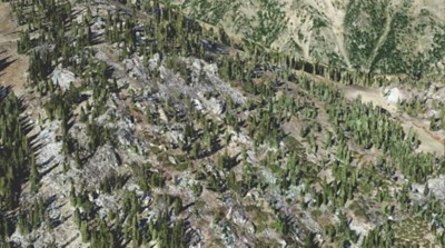 3D scene viewer with SURE mesh in Site Scan Manager for ArcGIS
The data captured at Jackson Hole with Site Scan for ArcGIS came out phenomenal as a result of the Terrain Follow feature. I don't think we could have captured the data we did without it.
Schedule a conversation with one of our experienced sales consultants. Tell us how you're using imagery and remote sensing data now, and we'll show you where a complete geospatial system can take your work next.